In summary:
- Navigating Hong Kong requires understanding the ‘why’ behind its transport rules, not just following a map.
- Citymapper is more than a route planner; it’s a diagnostic tool for solving the city’s unique mobility puzzles.
- Mastering multi-modal travel—seamlessly switching between the MTR, buses, and ferries—is key to efficiency.
- Local quirks, like frigid AC or specific minibus etiquette, are system features you can leverage with the right data.
For the tech-reliant traveler, Hong Kong presents a paradox. It’s a city with one of the world’s most advanced public transport networks, yet navigating it can feel like solving a complex puzzle. Many guides will give you the standard advice: get an Octopus card, stick to the MTR, and avoid rush hour. While true, this advice barely scratches the surface. It tells you the ‘what’, but completely ignores the ‘why’—the underlying system logic that governs the city’s flow.
What if the key wasn’t just to follow a route, but to understand the system that generates it? As an urban transport app developer, I see cities as complex systems of nodes, routes, and user behaviors. The real secret to navigating Hong Kong isn’t found in a travel blog, but in learning to think like the system itself. This is where Citymapper transcends being a simple map. While other apps show you the path, Citymapper gives you the data to understand the entire system, including local-specific modalities like red and green minibuses that are crucial for true mastery.
This guide isn’t about the app’s basic features. It’s a deep dive into using Citymapper as a diagnostic tool. We will deconstruct Hong Kong’s most common transport quirks and challenges, showing you how to use the app to make strategic, data-driven decisions. By understanding the ‘why’ behind long station walks, strict MTR rules, and frigid temperatures, you’ll learn to navigate not just like a local, but like a system architect.
This article deconstructs the core mobility puzzles of Hong Kong’s transport network. By exploring each specific challenge, you will learn how to apply a system-level approach to your travel, transforming Citymapper from a simple guide into a powerful strategic tool.
In this guide: How to Decode Hong Kong’s Transport System
- Why Are the Walks Between MTR Lines in Central Station So Long?
- What Is the Etiquette for Priority Seats on Hong Kong Transport?
- Why Is Public Transport in Hong Kong So Cold Even in Summer?
- Why Can You Be Fined HK$2000 for Drinking Water on the MTR?
- Red vs Green Minibus: Which One Can You Flag Down Anywhere?
- How to See the Big Buddha and The Peak in Just 12 Hours?
- Does the Tourist Octopus App Work on Android Phones Without NFC?
- How to Navigate Admiralty Station During Rush Hour Without Panic?
Why Are the Walks Between MTR Lines in Central Station So Long?
From a system design perspective, a station like Central is not just a single point but a massive, multi-layered interchange node. The long walks you experience are a direct consequence of its historical evolution and physical constraints. The station was built in stages, connecting separate lines (Tsuen Wan and Island) that were not originally designed for a seamless interchange. Furthermore, Hong Kong Station, serving the Tung Chung Line and Airport Express, was later connected via a subterranean pedestrian network. This results in a sprawling complex with a distance of almost 700 meters between its easternmost and westernmost exits.
This isn’t a design flaw; it’s a solution to a complex engineering problem: retrofitting connectivity into one of the densest urban environments on Earth. The long, air-conditioned tunnels with moving walkways are the system’s compromise to link these critical network arteries without disrupting the city above ground. Citymapper is invaluable here. It doesn’t just show the interchange as a single point; it factors the significant walking time into its total journey calculation. This allows you to make informed decisions, such as choosing a slightly longer MTR route with a simpler transfer over a seemingly shorter one that involves a 10-15 minute underground trek.
User Experience: The Hong Kong Station to Central Station Interchange
For tech-reliant travelers, the reality of this interchange is a key data point. User reports confirm the walk between the Airport Express’s Hong Kong Station and the main Central Station hub takes approximately 10 minutes. This journey, covering 300-500 meters, is fully underground through climate-controlled corridors, often equipped with moving walkways. While clear signage helps, navigating multiple levels during crowded rush hours can make this transfer feel longer. Citymapper’s algorithm, by accounting for this « human factor » time, provides a much more realistic travel estimate than a simple line-on-a-map view would suggest.
Understanding this aspect of the system’s architecture is the first step to mastering it. The walk is a feature, not a bug, and planning for it is crucial for an efficient journey.
What Is the Etiquette for Priority Seats on Hong Kong Transport?
The approach to priority seats in Hong Kong is a perfect example of a system-wide user experience (UX) initiative. It’s not just a suggestion but a deeply ingrained social norm, reinforced by consistent visual design across different transport modalities. From a developer’s perspective, this is a well-implemented feature designed to improve accessibility and passenger flow. The core etiquette is simple: these seats are intended for the elderly, pregnant women, passengers with children, and those with disabilities. While not legally mandated for you to give up the seat, it is strongly expected socially. Occupying one when a person in need is standing is considered highly impolite.
The system’s designers have made identification easy. You don’t need to read Chinese; you just need to recognize the visual cues. This consistent design language is crucial for a system handling millions of international visitors. The key is to be aware of your surroundings and proactively offer the seat. This simple act is one of the quickest ways to blend in and show respect for local customs.
The visual markers are consistent and clear across the network:
- Franchised buses: Seats near the doors have cushions and headrests in a different, often warmer, color than standard seats.
- MTR trains: Since the 2009 campaign, large red stickers featuring a smiley face clearly demarcate these seats.
- Minibuses: The single seat closest to the entrance is typically the designated priority seat.
- Trams: On the lower deck, seats near the driver are marked for priority use.
As the image highlights, the design often relies on a simple yet effective contrast in color and texture. This makes the priority seat instantly recognizable, even in a crowded vehicle. For a traveler, recognizing this pattern is part of decoding the local transport language. It’s a non-verbal rule that keeps the system running smoothly for everyone.
Why Is Public Transport in Hong Kong So Cold Even in Summer?
The aggressive air conditioning on Hong Kong’s public transport is a feature, not a bug, born from a combination of climate, public health, and crowd management. For a traveler unprepared, the temperature shock can be intense. From a system design standpoint, the goal is to create a stable, controlled environment within a transport network that operates in a hot and humid subtropical climate. The target is consistency. Research shows that the MTR maintains a stable interior climate, with temperatures set to an average of 20.5°C in MTR trains, often 10-15 degrees colder than the outside.
There are several engineering and social reasons for this. First, heat and humidity are the enemies of electronics and hygiene. The cold, dry air reduces the risk of equipment failure and slows the growth of bacteria in a crowded environment. Second, it’s a form of crowd psychology. The cool environment is perceived as a mark of efficiency and modernity. After walking through the sweltering city, stepping into a chilled MTR car is a form of relief that enhances the overall passenger experience, even if it feels extreme.
Finally, it’s about managing thermal load. An empty bus or train car at 20°C will naturally warm up as dozens of people, each a human radiator emitting body heat, get on board. The system is calibrated to handle the maximum passenger load during peak hours, ensuring the environment remains tolerable even when packed. For the tech-reliant traveler, this is a crucial piece of data. Citymapper might route you onto a 45-minute bus journey. Knowing the system’s « cold feature » means you’ll pack a light jacket or scarf, turning a potentially uncomfortable trip into a pleasant one. It’s about using data to adapt to the system’s unstated rules.
Why Can You Be Fined HK$2000 for Drinking Water on the MTR?
The strict prohibition of eating and drinking within the MTR’s paid areas is one of the system’s most rigorously enforced rules. The significant penalty, a HK$2,000 fine for consuming food or beverages, underscores its importance. From a system management perspective, this rule is not about punishing thirsty passengers; it’s about maintaining three core pillars of the user experience: cleanliness, safety, and efficiency. Spills can create slip hazards on floors and escalators, leading to accidents and delays. Food debris attracts pests, compromising the hygiene of the entire network. The lingering smell of food in enclosed, air-conditioned spaces also degrades the passenger environment for everyone.
By enforcing a blanket ban, the MTR Corporation removes any ambiguity and ensures a consistently clean and safe environment, which is a key part of its brand and operational promise. For a Citymapper user, this rule has strategic implications. If you’re planning a long, multi-leg journey on a hot day, you must factor in « hydration stops » outside the MTR paid areas. This is where Citymapper’s multi-modal capabilities shine. You might see a route that’s 5 minutes faster via MTR, but choosing an alternative on a bus or ferry, where rules are more relaxed, could be the better strategic choice if you need to eat or drink en route.
This table illustrates how the food and drink policy varies across different transport modes, a critical data layer for any strategic journey planning in Hong Kong.
| Transport Mode | Food/Drink Policy | Enforcement | Citymapper Consideration |
|---|---|---|---|
| MTR (paid areas) | Prohibited | HK$2,000 fine | Plan hydration stops before/after MTR journeys |
| Star Ferry | Generally acceptable | No specific prohibition | Better option for longer cross-harbour trips in hot weather |
| Franchised Buses | Generally acceptable | No specific prohibition | Alternative to MTR for routes where you need to eat/drink |
| Trams (Ding Ding) | Generally acceptable | No specific prohibition | Slower but more relaxed for casual sightseeing with refreshments |
Ultimately, the fine is a deterrent designed to protect the integrity of the transport system. Knowing this rule isn’t just about avoiding a penalty; it’s about understanding the priorities of the network you’re using.
Red vs Green Minibus: Which One Can You Flag Down Anywhere?
For any traveler aiming for true local-level navigation, understanding the minibus system is non-negotiable. It’s a vital, flexible layer of the transport network that fills the gaps left by the MTR and large buses. The core distinction lies in their operational model: Green Minibuses (GMBs) operate on fixed routes with fixed fares, much like standard buses. In contrast, Red Minibuses (RMBs) offer a more dynamic, semi-regulated service. And to answer the crucial question: it is the Red Minibus that you can often flag down anywhere along its route, provided it’s safe to stop.
Green Minibuses, with their network of around 550 various routes and 3,300 vehicles, are fully integrated into journey planners like Citymapper. You can see their routes, stops, and schedules, making them easily accessible for tech-savvy travelers. They are predictable and reliable. Red Minibuses are the ‘expert mode’ of Hong Kong transport. Their routes can be fluid, fares can vary by time of day, and they often lack English signage. While you can flag them down, you also need to know how to tell the driver where you want to get off, often in Cantonese.
For most visitors, the Green Minibus is the perfect entry point into this layer of the transport system. Citymapper excels at integrating GMBs into your multi-modal journey, often presenting them as the most efficient way to get to a final destination from a major MTR or bus node. By using the app, you can confidently use this hyper-local transport mode without the steep learning curve of the red minibus system, reaping the benefits of its extensive reach into residential areas and scenic spots.
How to See the Big Buddha and The Peak in Just 12 Hours?
This is a classic Hong Kong itinerary optimization problem. It involves two of the most popular—and logistically challenging—attractions, separated by significant distance and multiple transport modes. Attempting this without a solid plan is a recipe for failure. From a system developer’s viewpoint, this isn’t a single journey but a complex sequence of timed events. Success depends on efficient routing, accurate time estimation, and accounting for known system bottlenecks, like queues. This is precisely the kind of challenge where Citymapper’s advanced features become indispensable.
The core task is to create a personal travel algorithm that balances travel time, attraction opening hours, and desired experiences (like sunset at The Peak). Simply looking at a map is insufficient. You need to process multiple data layers: MTR schedules, bus frequencies, ferry timetables, and the operational hours of the Ngong Ping 360 cable car and the Peak Tram. Citymapper automates this data aggregation, allowing you to focus on strategic decisions rather than manual research. The « Arrive by » function is particularly powerful, letting you work backward from a key event like sunset to build a viable timeline.
However, no app can perfectly predict real-world queues. The crucial final step is to overlay your own « human » data onto the app’s plan by adding buffer time for these known, non-trackable delays. A successful 12-hour itinerary is the perfect synthesis of the app’s computational power and your strategic oversight.
Your action plan: Citymapper Workflow for a Complex Itinerary
- Pin both destinations: Before your travel day, search and save ‘Ngong Ping 360’ (for the Big Buddha) and ‘The Peak Tram’ as favorite locations in Citymapper for quick access.
- Compare sequence options: Use the ‘Get Me Somewhere’ feature to compare total journey times for a Buddha-first versus Peak-first route. Factor in your preference for daylight at the Buddha versus sunset at The Peak.
- Set arrival time constraints: To catch the sunset, use the ‘Arrive by’ function to plan your arrival at The Peak. Hong Kong’s sunset is typically between 6-7 PM, so check the specific time for your date of travel.
- Account for non-trackable delays: The app’s estimates are for travel time only. Manually add a buffer of at least 45-60 minutes for potential queues at the Ngong Ping 360 cable car and 30-45 minutes for the Peak Tram, especially on weekends.
- Save complete itinerary for offline use: Once you’ve finalized your plan, use Citymapper’s save feature. This stores the full multi-leg journey, ensuring you have access to it even in underground MTR sections with no signal.
By following this workflow, you move from being a passive user to an active planner, using the app’s tools to build a robust and realistic itinerary.
Does the Tourist Octopus App Work on Android Phones Without NFC?
The short answer is no. The Tourist Octopus App, like other mobile Octopus functionalities, relies on Near Field Communication (NFC) technology to interact with payment readers. If your Android phone does not have an NFC chip, you cannot use it as a mobile Octopus card. This is a hardware limitation, not a software one. From a system perspective, the Octopus network is built on a specific, secure communication protocol that requires this physical hardware component to function.
For a tech-reliant traveler whose phone lacks NFC, this can seem like a major roadblock. However, it’s simply a data point that requires a change in strategy. The Hong Kong transport system has multiple redundant payment solutions. Your task is to choose the best alternative based on your specific travel patterns, length of stay, and budget. Citymapper continues to be a vital tool regardless of your payment method, as its fare estimation features work just as well when you’re using a physical card.
Instead of being stopped by the lack of app compatibility, a savvy traveler uses this information to select the most efficient physical alternative. The table below, based on data from travel experts at Hong Kong Cheapo’s transport guide, outlines the primary options for non-NFC Android users, helping you make a data-driven choice.
| Payment Option | Initial Cost | Deposit Required | Citymapper Integration | Best For |
|---|---|---|---|---|
| Physical Tourist Octopus Card | HK$39 (non-refundable) | No | Fare estimates accurate | Short visits, convenience priority |
| Standard On-Loan Octopus Card | HK$50 (refundable deposit) | Yes (HK$50) | Fare estimates accurate | Longer stays, budget-conscious travelers |
| Single Journey Tickets | Per journey | No | Fare calculator works | Very occasional MTR use only (not recommended) |
| Contactless Bank Cards | Free (if you have one) | No | Supported at select stations | 2023+ travelers with compatible cards |
The key takeaway is that the system provides multiple entry points. The lack of one specific technology on your device doesn’t lock you out; it simply requires you to pivot to a different, equally viable solution.
Key takeaways
- Master Hong Kong transport by understanding the ‘why’ behind its rules, not just by following a map.
- Treat strict rules like the MTR food ban and frigid AC not as inconveniences, but as system features to plan around.
- Leverage Citymapper as a multi-modal strategy tool, choosing between MTR, bus, or ferry based on time, cost, and comfort.
- True navigation mastery comes from combining the app’s data with an understanding of the system’s physical and social logic.
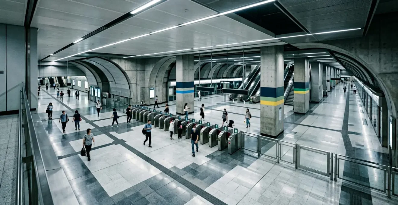
How to Navigate Admiralty Station During Rush Hour Without Panic?
Admiralty Station is the ultimate stress test for any Hong Kong navigator. It’s a critical interchange node connecting four major MTR lines (Island, Tsuen Wan, South Island, and East Rail), making it one of the busiest and most complex stations in the entire system. During rush hour, the platform experience can be overwhelming. As travel experts note, the sheer volume of passengers creates a unique challenge. In their guide to the MTR, the team at Hong Kong Cheapo points out the severity of the situation.
Some stations such as the Admiralty and North Point can get extremely crowded during rush hour as these stations are major interchange stations. You will sometimes have to wait for three or four trains.
– Hong Kong Cheapo travel guide, Navigating Hong Kong’s MTR System guide
From a system perspective, this is a capacity problem. When demand exceeds the throughput of trains, queues form. Panic is the result of being unprepared for this reality. A strategic navigator, however, uses data to avoid this situation entirely. The key is to treat « rush hour » not as a time to avoid, but as a dynamic data layer that influences your routing algorithm. Citymapper is your primary tool for this. Check the journey time a few minutes before you leave; the app’s real-time data will often show significantly longer travel times during peak congestion, giving you an early warning.
The solution is not to push through the crowd, but to route around the problem. Use Citymapper to compare alternatives. Is there a bus route that bypasses Admiralty? Could a short ferry trip and a different MTR line be faster than waiting for three trains? Often, a multi-modal journey that looks more complex on the map is far more efficient and pleasant than facing the bottleneck at a major interchange node. Avoidance and rerouting are the pro-level strategies, and Citymapper provides the data to execute them effectively.
Apply this system-thinking approach to your own Citymapper plans. By treating every journey as a mobility puzzle to be solved with data, you transform yourself from a tourist following a line on a screen into a master navigator of Hong Kong’s complex, efficient, and fascinating transport network.