Visiting Yim Tin Tsai isn’t a sightseeing tour; it’s a logistical test that rewards preparation over spontaneity.
- Success means decoding sporadic ferry timetables, choosing the right chemical defenses against local pests, and understanding the legal line between exploring and trespassing.
- The difference between a memorable expedition and a miserable failure lies in your self-sufficiency, especially regarding hydration in Hong Kong’s unforgiving climate.
Recommendation: Approach this trip as a planned expedition: pack for self-sufficiency, study your access routes, and respect the island’s silent history.
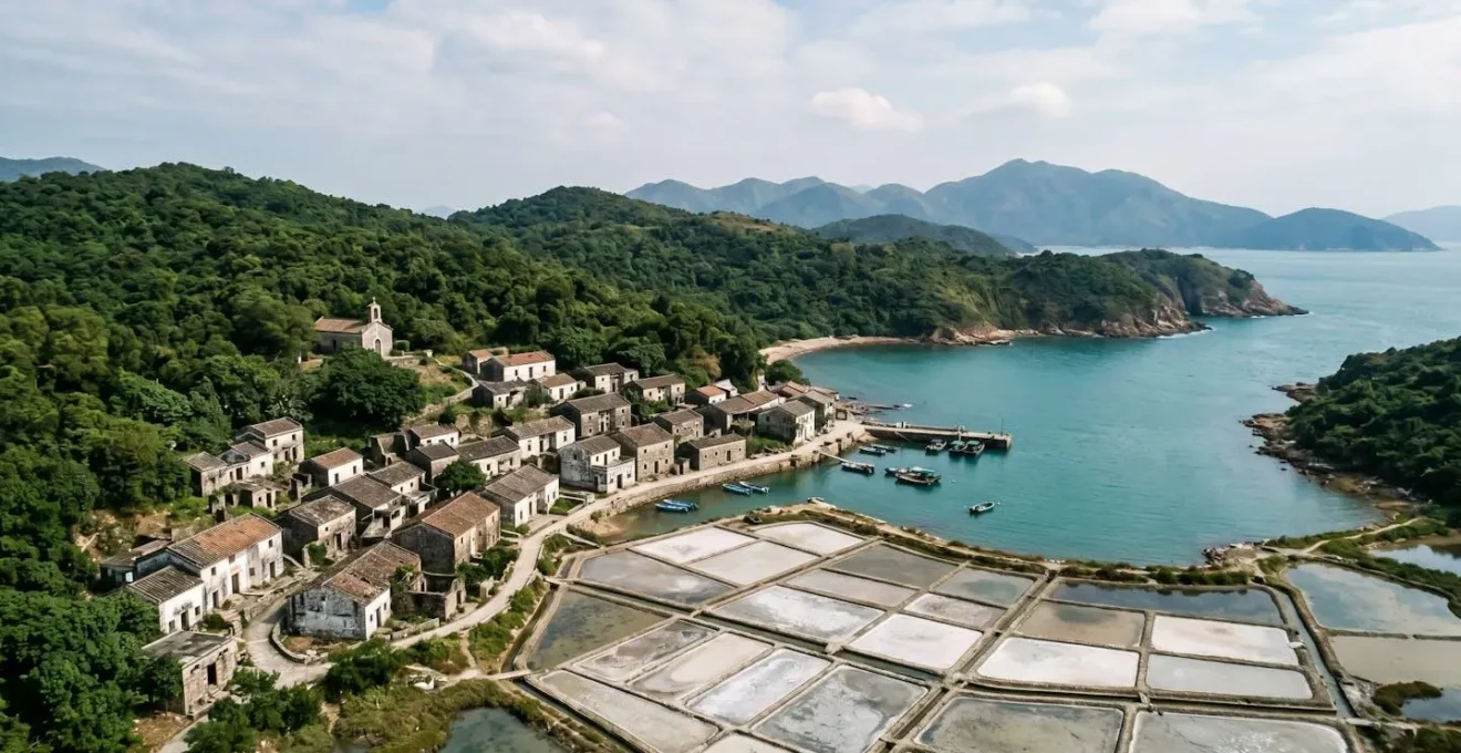
In a city of relentless verticality and neon-drenched nights, the call of the void is strong. For the urban explorer, Hong Kong’s true treasures aren’t in its gleaming malls, but in its forgotten peripheries—the crumbling Hakka houses, the overgrown trails, and the silent, salt-laced air of its ghost villages. Yim Tin Tsai is often the first name on any explorer’s list. Standard advice will tell you to simply check the ferry schedule and pack some water. This is dangerously simplistic.
This approach treats an expedition like a commute, ignoring the very real challenges that make these locations so rewarding. It overlooks the cryptic nature of kaito ferry timetables, the specific ecological threats like sandflies that can ruin a day, and the very real legal risks of stepping one foot off the designated path. The key to unlocking these places isn’t just about finding them; it’s about mastering the unseen infrastructure and environmental realities that guard them.
Forget the tourist mindset. This guide is a tactical field manual. We’re moving beyond the « what » and into the « how » and « why ». We will dissect the logistical puzzles, the environmental threats, and the legal grey areas. This is the intelligence brief you need before undertaking an expedition to Yim Tin Tsai or any of Hong Kong’s other abandoned frontiers. It’s time to prepare for the reality of the mission, not the fantasy of the postcard.
This field manual is structured to build your expertise sequentially, from core logistics to advanced applications. Each section provides the critical intelligence needed to operate effectively and safely in Hong Kong’s remote territories.
Summary: A Tactician’s Guide to Hong Kong’s Forgotten Islands
- How to Read the Sporadic Schedules of Small Kaito Ferries?
- What Repellent Works Best for Sandflies on Remote Beaches?
- Is the Hike to the Abandoned Ma Wan Village Legal?
- Why Must You Bring All Your Own Water When Hiking Remote Trails?
- Where to Find Authentic Hakka Cuisine in Remote Villages?
- Why Do Star Ferry Sailors Use Billhooks to Catch the Mooring Ropes?
- Why Are Ferry Queues to Cheung Chau So Long During the Festival?
- How to See the Hexagonal Rock Columns of the UNESCO Global Geopark?
How to Read the Sporadic Schedules of Small Kaito Ferries?
The first filter that separates explorers from tourists is the kaito. These small, often family-run ferries are the lifeblood of the outlying islands, but their schedules are a world away from the MTR’s predictable pulse. Forgetting the « tap-and-go » mentality is your first mission. Kaito schedules are not mere suggestions; they are rigid, infrequent, and often unannounced online. Many are only posted on a weathered board at the pier itself. Assume the last ferry of the day is non-negotiable—missing it could mean an unplanned, and potentially unsafe, overnight stay. The complexity of this system is vast; the Hong Kong kaito network operates on 78 fixed routes, each with its own quirks.
Your tactical approach should be threefold. First, photograph the schedule at your departure pier (e.g., Sai Kung for Yim Tin Tsai) and your arrival pier. They are not always identical. Second, note that schedules change for weekends, public holidays, and even informally due to weather. A weekday schedule is useless on a Saturday. Third, always have a cash buffer. Many kaitos do not accept Octopus cards, and you don’t want to be stranded for the sake of a few dozen Hong Kong dollars. Mastering the kaito is the first step in logistical mastery; it’s about acknowledging that you are operating on island time, not city time.
What Repellent Works Best for Sandflies on Remote Beaches?
On Hong Kong’s remote beaches, mosquitoes are a nuisance, but sandflies are a tactical threat. These tiny, almost invisible insects deliver bites that can cause intense itching, welts, and discomfort lasting for weeks, seriously compromising your ability to operate. Standard, low-concentration repellents that work in urban parks are utterly insufficient. Your choice of chemical defense is a critical piece of gear, not an afterthought. The primary decision is between products containing DEET and those with Picaridin as the active ingredient. Each has distinct operational advantages and disadvantages.
DEET is the long-standing gold standard for effectiveness but comes with downsides: it can feel greasy, has a strong odor, and famously damages plastics and synthetic materials—a significant risk for expensive watches, camera gear, and technical clothing. Picaridin is a newer alternative that offers comparable protection against many insects, is less irritating to the skin, and is gear-safe. For the serious explorer whose kit is as important as their comfort, Picaridin is often the superior choice. Ankle and wrist areas are primary targets for sandflies, so application must be thorough.

This choice is about balancing proven efficacy with material preservation. Your personal risk assessment should consider your skin sensitivity and the value of your gear when choosing your defense. As this comparative analysis shows, the right choice is highly context-dependent.
This table, based on data from consumer council tests and health authority warnings like those reported by the South China Morning Post, breaks down the key differences:
| Characteristic | DEET (20-30%) | Picaridin (20-25%) |
|---|---|---|
| Effectiveness against sandflies | High (up to 80% protection for 4+ hours) | High (up to 80% protection for 4+ hours, 8 hours against biting flies) |
| Skin irritation risk | Moderate to high (rashes, blisters possible, especially in children) | Low (causes less skin irritation than DEET) |
| Damaging to gear | Yes (dissolves plastics, synthetics, watch crystals) | No (safe for plastics and gear) |
| Greasy feel | Yes (heavy, oily residue) | No (less greasy, more comfortable) |
| Recommended by Hong Kong authorities | Yes (Consumer Council tested, effective) | Yes (alternative for those avoiding DEET) |
Is the Hike to the Abandoned Ma Wan Village Legal?
This is the central question for any serious urban explorer in Hong Kong. The allure of « abandoned » places like the old Ma Wan village or derelict schools is powerful, but the word itself is a legal minefield. In Hong Kong, « abandoned » does not mean « publicly accessible. » Nearly every square inch of land is owned by the government, a private developer, or a clan. Crossing a dilapidated fence, pushing open a gate, or entering a structure without explicit permission is trespassing. The law is brutally clear on this point. As legal resources like Family CLIC state, intent is not a defense. The Hong Kong Land Law framework is stark.
As experts in Hong Kong’s legal framework on property rights clarify:
If the defendant intends to enter the land on which he trespassed, it is no defence that he mistakenly thought that it was his own land or that he had authority to be there.
– Hong Kong Land Law, Family CLIC – Trespass to Land Legal Framework
This isn’t a theoretical risk. Authorities have demonstrated a willingness to prosecute, especially when explorations are publicized. The line between documentation and transgression is thin, and the consequences are real. The prudent explorer understands that true exploration involves respecting these boundaries, focusing on what can be seen from public paths and using a long lens for what cannot. The thrill is in the discovery, not the infraction.
Case Study: The Price of a Viral Video
The risks of ignoring these laws were highlighted when, as reported by the Hong Kong Free Press, two YouTubers were charged in August 2023 for trespassing into abandoned correctional facilities on Lantau Island. Despite the sites appearing derelict, they were still government property. Their mission to film content for their channel resulted in criminal charges under the Summary Offences Ordinance, which carries penalties of up to three months’ imprisonment. This case serves as a stark reminder: « abandoned » does not equal « permission, » and a camera is not a legal shield.
Why Must You Bring All Your Own Water When Hiking Remote Trails?
In Hong Kong’s subtropical climate, hydration is not just about comfort; it’s a critical mission parameter. The humidity is a deceptive enemy, accelerating fluid and electrolyte loss at a rate that city-dwellers are unprepared for. On remote trails, especially exposed ridges with no shade, the idea of « finding » water is a dangerous fantasy. There are no taps, and streams are often contaminated or have run dry. Your water supply is your lifeline, and you are entirely responsible for it. Assuming you can « get by » with a single 500ml bottle is the most common and potentially fatal mistake a novice explorer can make. Heatstroke is a swift and unforgiving adversary.
An expeditionary mindset requires a quantitative approach to hydration. This means calculating your needs before you even step on the trail. You need to carry not just water, but also the electrolytes (sodium, potassium) lost through sweat. Plain water alone is not enough; in extreme cases, drinking excessive amounts of plain water can lead to hyponatremia, a dangerous condition where sodium levels in the blood become diluted. Your hydration strategy must be comprehensive, covering pre-hike preparation, on-trail consumption, and post-hike recovery.

The isolation of these trails means self-rescue is your primary plan. A dehydration-induced headache or dizziness can quickly escalate a manageable hike into a serious emergency. There is no room for error.
Your Hydration Action Plan for Hong Kong Trails
- Pre-load: Drink 500ml of water upon waking and add salt to your breakfast. Don’t start your hike already in a deficit.
- Calculate your carry: A minimum of 1 liter per hour of moderate hiking is the baseline. For exposed summer trails, this can increase to 1.5-2 liters per hour.
- Pack electrolytes: Bring oral rehydration salts, salt tablets, or sports drinks. They are as crucial as the water itself.
- Choose salty snacks: Pack trail mix, crackers, or dried fruits to replenish sodium and potassium lost through sweat.
- Recognize the signs: Learn the symptoms of dehydration—throbbing headache, dizziness, cessation of sweating—and take immediate action by seeking shade and hydrating if they appear.
Where to Find Authentic Hakka Cuisine in Remote Villages?
This question is more complex than it appears, touching upon the very essence of a « ghost village. » The honest answer for places like Yim Tin Tsai is that you largely don’t. Authentic Hakka cuisine is a product of people—of a living, breathing community. The tragedy and allure of these villages is that the community is gone. The salt pans are dormant, the fish farms are empty, and the kitchens are cold. While Yim Tin Tsai has a small, dedicated group working on its revitalization, including a small eatery that sometimes operates on weekends, you cannot simply show up expecting a bustling restaurant scene. This tiny island, which once supported a population of 1,200 people through farming, fishing, and salt-making, is now a place of memory.
To find authentic Hakka food, the explorer must look to where the people went. This means seeking out restaurants in the market towns that serve the surrounding islands, like Sai Kung or Tai Po. Here, you will find the culinary heritage of the Hakka people, not as a tourist attraction, but as daily fare. Dishes like pork belly with preserved vegetables (mui choi kau yuk) or salt-baked chicken (yim guk gai) are the real artifacts. So, the quest for authentic food in a remote village transforms into a historical one: you visit the village to understand the silence and the history, and then you travel to the living towns to taste the culture that once thrived there. The alternative is to find the rare, pre-booked private kitchen experiences on islands with small remaining populations, which requires significant advance planning—another hallmark of the expeditionary mindset.
Why Do Star Ferry Sailors Use Billhooks to Catch the Mooring Ropes?
Observing the Star Ferry docking is to witness a piece of living history and a masterclass in efficiency. While not a remote kaito, the technique used by its sailors is a perfect example of the human-led, time-tested systems that an explorer should appreciate. The tool in question is a billhook, known as a *gai gou* in Cantonese. In an age of automation, this simple hook-on-a-stick might seem archaic, but it is a highly specialized and brutally effective solution perfected over more than a century of operation in the crowded, fast-flowing waters of Victoria Harbour.
The billhook is not just for pulling; it’s a multi-purpose instrument of seamanship. It provides the sailor with a crucial 1-2 meters of extended reach, allowing them to snag a heavy, wet hawser (mooring rope) from the pier with precision. It then becomes a lever, giving the crew member the mechanical advantage needed to control a rope weighing over 10 kilograms and secure the vessel against the pier’s massive tires. This entire manual process, from approach to secure mooring, is often completed in under 30 seconds—a speed and reliability that expensive automated systems would struggle to match, especially given the short 8-minute crossing time. It is a testament to the idea that the most advanced solution is not always the most technological one.
Heritage in Motion: The Billhook Technique
The Star Ferry’s mooring technique is a skill passed down through generations. It represents a deep understanding of the harbour’s currents, the vessel’s momentum, and the physics of leverage. This is not a job you can learn from a manual; it is learned through apprenticeship on the deck, a form of hand-eye coordination and muscle memory that embodies Hong Kong’s maritime soul. For the explorer, it’s a reminder to look for the hidden expertise and human ingenuity that underpins the city’s infrastructure, both old and new.
Why Are Ferry Queues to Cheung Chau So Long During the Festival?
During the annual Cheung Chau Bun Festival, the Central Pier 5 transforms into a case study in human logistics and crowd dynamics. The « why » is simple: a massive, temporary population shift. You have a significant portion of a 7.5 million-person metropolis attempting to descend upon a tiny island that can only be reached by ferry. As official sources like the Hong Kong Tourism Board note, the festival can draw upwards of 200,000 visitors, all funneling through a handful of ferry gates. This creates a bottleneck of epic proportions, with queue times easily stretching into hours. For the unprepared, the festival experience begins and ends with waiting in a line.
However, for the tactical explorer, a crowd is just another environmental factor to be navigated. Applying the expeditionary mindset means you don’t join the queue; you out-think it. This involves understanding crowd flow, timing, and alternative routes—the « unseen infrastructure » of human movement. The main herd arrives late morning and attempts to leave immediately after the main parade. The savvy explorer operates outside these peak times, using counter-intuitive strategies to bypass the worst of the congestion. It’s not about enduring the crowd; it’s about making the crowd irrelevant to your mission.
Pro-Level Queue Avoidance Strategies
- The Counter-Flow Route: Take the inter-island kaito from Mui Wo on Lantau Island to Cheung Chau. This route is a local secret and is significantly less crowded.
- The Dawn Raid: Catch the first ferry from Central around 6:30 am. You’ll arrive before the main crowds and get to experience the island waking up.
- The Pre-emptive Extraction: The main parade ends late, triggering a mass exodus. Plan your departure for mid-afternoon (2-3 pm) to get ahead of the crush.
- The Waterborne Approach: Forgo the island entirely. Charter a junk boat to watch the festivities from the harbor, offering a unique perspective without the crowds.
- The Overnight Gambit: The ultimate move is to book accommodation months in advance and travel the day before, turning the logistical challenge into a leisurely stay.
Key takeaways
- Logistical Mastery: Your expedition’s success is determined before you leave. Master ferry schedules, alternative routes, and timing to make challenges irrelevant.
- Expeditionary Mindset: Always be self-sufficient. Carry more water and supplies than you think you need, understand your gear’s limitations, and be prepared for zero support.
- Calculated Risk: « Abandoned » is a legal status, not an invitation. Know the laws, respect property lines, and understand that the best exploration is sustainable and respectful.
How to See the Hexagonal Rock Columns of the UNESCO Global Geopark?
The final frontier for many Hong Kong explorers is the Hong Kong UNESCO Global Geopark, home to world-class hexagonal volcanic rock columns. This is not a single location but a vast territory. As the Hong Kong Tourism Board notes, « The tiny island of Ap Chau and its larger neighbour, Kat O… form part of the Hong Kong UNESCO Global Geopark. » Reaching these formations in the Sai Kung Volcanic Rock Region requires the culmination of all the skills discussed: logistical planning, physical preparedness, and choosing the right method of approach for your skill level and objective. There is no single « best » way; there is only the best way for your mission profile.
Your choice of transport dictates the entire experience. A guided boat tour offers efficiency and expert commentary, ideal for a reconnaissance mission. The land-based approach, combining a taxi with a hike, demands greater physical fitness and self-sufficiency but offers more freedom. The most advanced method, kayaking, provides unparalleled, intimate access to sea caves and remote coastlines but requires significant experience, gear, and an understanding of marine conditions. Each option represents a different balance of cost, effort, and reward. Choosing your route is the final test of your ability to plan and execute an expedition.
This decision matrix, based on information from official guides and tour operators, helps you select the right approach for your expeditionary goals.
| Access Method | Difficulty Level | Duration | Cost (HKD) | Best For |
|---|---|---|---|---|
| Boat Tour from Sai Kung Pier | Easy | 3-4 hours (half-day tour) | $200-350 per person | Families, photographers, casual visitors who want guided narration and comprehensive coastal views |
| Taxi to East Dam + Hiking | Moderate | 4-6 hours (taxi + 2-3 hour hike) | $150-200 (shared taxi) + entry fee | Active hikers who want to combine geological features with scenic reservoir views and exercise |
| Kayaking from Tai Wan Beach | Advanced | Full day (6-8 hours) | $300-500 (rental + guide) | Adventure seekers and experienced paddlers wanting to explore sea caves and untouched formations up close |
Ultimately, whether you are exploring the silent halls of Yim Tin Tsai or the epic geology of the Geopark, the principle remains the same. Success is not an accident; it is the result of meticulous planning, an expeditionary mindset, and a deep respect for the logistical, environmental, and legal realities of the field. Start planning your next expedition today.