The most crucial takeaway is that Hong Kong’s hexagonal columns are geologically rarer and more magnificent than many world-famous counterparts, but accessing this remote wonder requires strategic planning to avoid being stranded.
- These columns are composed of light-coloured, silica-rich rhyolitic tuff, a stark contrast to the common dark basalt of sites like the Giant’s Causeway.
- Securing your return transport from the isolated East Dam is the single most critical logistical challenge you will face.
Recommendation: Before you even think about sightseeing, your first step must be to arrange your return taxi or confirm the limited public transport schedule. This guide shows you how.
The sight of thousands of colossal rock columns, arranged in an almost perfect hexagonal matrix, is a humbling spectacle. It feels like witnessing the planet’s own architectural blueprint. For most visitors, the journey to the Hong Kong UNESCO Global Geopark is about capturing this breathtaking view. But this approach often misses the profound story etched into the stone and frequently ends in the logistical nightmare of being stranded at the remote High Island Reservoir East Dam with no way back to civilization.
Common advice often boils down to « take a taxi » or « walk the trail. » This is dangerously simplistic. This is not a typical tourist destination; it’s a geological expedition. To truly appreciate what you’re seeing, you need to understand the science behind it—the cataclysmic supervolcano eruption 140 million years ago, the unique chemical composition of the rock, and the sheer scale that dwarfs other famous sites. More importantly, you need the logistical savvy to navigate the journey successfully.
Forget the surface-level tourist tips. This guide adopts the perspective of a geologist. We will delve into the *why*—why these columns are a light pinkish-grey, not black; why they are so massive; and why they represent one of the world’s most spectacular examples of columnar jointing. We will equip you with the practical strategies for transport, exploration by sea and land, and how to read the landscape, turning a simple visit into a genuine geological discovery.
This article provides a comprehensive field manual for your expedition. We’ll cover the critical logistics of transport, the best ways to experience the formations, the science that makes them unique, and even some fascinating detours in the surrounding area. Let’s begin your journey into Earth’s deep history.
Summary: A Geologist’s Field Guide to the Hexagonal Columns
- Is It Easy to Get a Taxi Back from High Island Reservoir East Dam?
- Where to Book a Geopark Boat Tour to See the Sea Arches?
- How Long Is the High Island Geo-trail Walk for Families?
- Why Are Hong Kong’s Hexagonal Columns Different from the Giant’s Causeway?
- Is the Volcano Discovery Centre in Sai Kung Worth Visiting Before the Park?
- How to Read the Sporadic Schedules of Small Kaito Ferries?
- Why Do Star Ferry Sailors Use Billhooks to Catch the Mooring Ropes?
- How to Visit the Ghost Village of Yim Tin Tsai for a Day Trip?
Is It Easy to Get a Taxi Back from High Island Reservoir East Dam?
Let’s be unequivocally clear: no, it is not. This is the single most critical point of failure for most visitors. The High Island Reservoir East Dam is beautiful precisely because it is remote, and this remoteness means there is no regular taxi queue, no ride-hailing app coverage, and extremely limited mobile signal. Arriving without a return plan is a recipe for being stranded for hours.
The solution lies in achieving what can be called « logistical sovereignty. » You must take control of your transport from the very beginning. The most reliable method is to forge a partnership with the taxi driver who takes you there. This isn’t a mere transaction; it’s a pre-negotiated service. The feeling of seeing other unprepared groups desperately trying to find a signal while your pre-arranged ride arrives is a testament to proper planning.
I was lucky that the two Hongkongers whom I cabbed with forewarned me about the difficulty of getting a cab down to Sai Kung from the East Dam, and helped me to get the taxi driver’s mobile number before we alighted.
– First-Timer Warning About Taxi Availability at East Dam
The cost from Sai Kung town is approximately HK$130 each way, a small price for certainty. The key is to treat your driver as a partner in your expedition. Agree on a pickup time (2-3 hours is typical for a decent exploration) and confirm the price for the return journey upfront. This simple act transforms the entire experience from a gamble into a well-executed plan.
Your Pre-Trip Logistics Audit
- Contact Point: Before you exit your taxi at the dam, have you asked for the driver’s mobile number and confirmed they serve the area for return trips?
- Price Agreement: Have you negotiated and agreed upon a fixed price for the return journey to Sai Kung Pier to avoid any surprises?
- Backup Plan: If your original driver is unavailable, do you have the number for their taxi dispatch company to call and request a car to your specific location (High Island East Dam)?
- Time Coordination: Have you set a clear, mutually agreed-upon pickup time that allows for your planned activities (e.g., Geo-trail walk)?
- Contingency: Do you have enough cash (HKD) to cover both legs of the taxi journey, as card payments are not guaranteed?
Where to Book a Geopark Boat Tour to See the Sea Arches?
While the view from the East Dam is magnificent, some of the Geopark’s most dramatic features are only visible from the water. Towering sea arches, carved through the hexagonal columns by millennia of wave action, create natural gateways of stone. To experience this, a boat tour is not just an option; it’s essential for any serious geology enthusiast. Booking a tour is straightforward, with options at Sai Kung Pier ranging from large public ferries to private speedboats.
Your choice depends on your objective. For a structured, educational experience, the official Recommended Geopark Guide (R2G) tours are excellent. They offer a deep dive into the region’s geology. For photographers or families wanting a customized itinerary, chartering a private speedboat offers unparalleled flexibility. Apps like Splitdyboat can help you find others to share the cost, making a private charter more accessible. You can set your own schedule, perhaps timing your visit for the « golden hour » light that makes the rhyolitic columns glow.
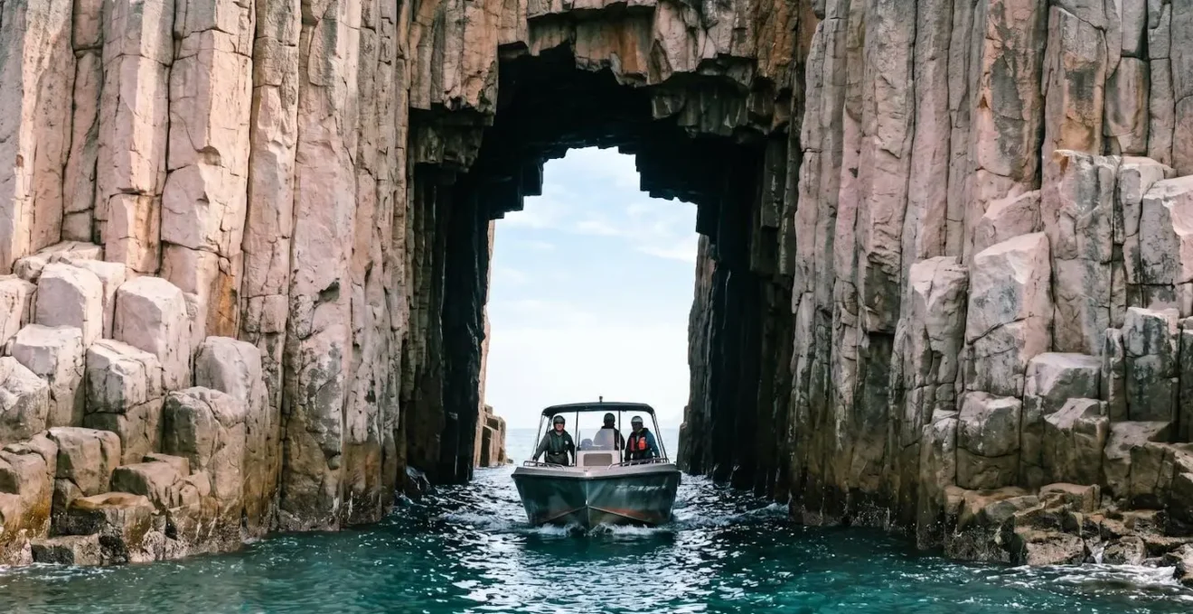
This perspective from the sea provides a true sense of scale. As your boat passes through a natural arch, you are completely enveloped by the colossal 100-meter-high columns, an experience impossible to replicate from land. The following table breaks down the primary options available directly from Sai Kung Pier, your main logistics hub for any marine exploration of the Geopark.
| Tour Type | Price Range (HKD) | Group Size | Flexibility | Best For | Booking Source |
|---|---|---|---|---|---|
| R2G Public Tour (Recommended Geopark Guide) | $380 per person | Small group (shared) | Fixed schedule & route | Solo travelers, budget-conscious visitors, educational focus | Hong Kong Tourism Board official promotion or Sai Kung Pier kiosks |
| Private Speedboat Charter | Varies by operator & season | Customizable (4-12 passengers typically) | High – choose timing, route, duration | Photographers (golden hour tours), families wanting custom pace, groups of 4+ | Splitdyboat, Viator, or direct negotiation at Sai Kung Pier |
| Standard Public Boat Tour | Varies by operator | Medium to large group | Midday departures, standard 2-3 hour routes | General sightseeing, group travelers | Klook, Sai Kung Pier kiosks |
How Long Is the High Island Geo-trail Walk for Families?
The High Island Geo-trail is a fantastic, accessible way to get up close with the formations. Officially, the Hong Kong Tourism Board suggests the walk takes about 3 hours, covering a distance of 3.3 km. However, this is a misleading metric for a geology enthusiast or a family. A « geologist’s pace » is not about speed; it’s about observation. You should budget at least 90 minutes for the trail itself, plus time at the dam, to truly appreciate the features.
Instead of thinking of it as a single walk, break it down into a series of geological discoveries. The trail is not just a path; it’s an open-air museum. The initial descent from the East Dam brings you face-to-face with the main attraction: the towering wall of hexagonal columns. This is your first opportunity to appreciate their scale and near-perfect geometry. But don’t stop there. Look closer.
Challenge yourself to find columns that aren’t hexagonal—about a third are actually pentagonal. Look for the stunning S-shaped, twisted columns near the base, evidence of ancient seismic activity that buckled the rock when it was still semi-plastic. Further along, you’ll encounter a dark dyke intrusion—a different type of magma that forced its way through weaknesses in the columns millions of years after they formed. The trail culminates at a wooden boardwalk leading towards a sea cave, offering a final, dramatic view before you make the return journey. This structured approach turns a simple family walk into an interactive lesson in physical geology.
A Geologist’s Field Guide to the Trail
- Segment 1 (0-15 min): Blue Anchor Monument: Start at the East Dam. The anchor monument is a memorial to workers who died during the reservoir’s construction, a moment to reflect on the human engineering that made this geological site accessible.
- Segment 2 (15-30 min): Descent to Trail Base: Keep an eye out for wild cattle. These unexpected wildlife encounters add a layer of life to the ancient stone landscape.
- Segment 3 (30-60 min): Main Column Wall: This is your primary study area. Hunt for pentagonal columns and the tell-tale S-shaped distorted columns, which are a highlight for any geologist.
- Segment 4 (60-75 min): Fault Breccia & Dyke Intrusions: Use the information boards to help you identify the darker, finer-grained basaltic dyke that cuts through the lighter rhyolitic tuff.
- Segment 5 (75-90 min): Sea Cave Boardwalk: The climax of the trail, offering a powerful view of coastal erosion at work on the columnar-jointed rock. A perfect final photo opportunity.
Why Are Hong Kong’s Hexagonal Columns Different from the Giant’s Causeway?
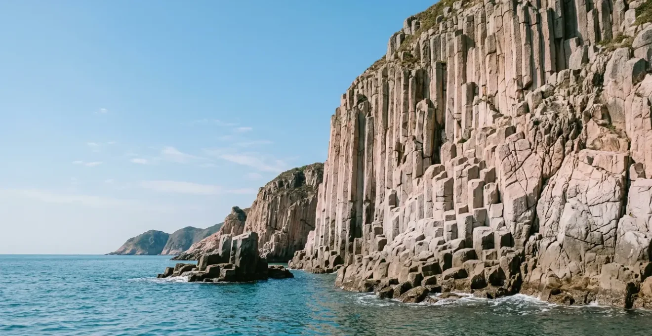
This is the most important question for any geology enthusiast. While the Giant’s Causeway in Northern Ireland is more famous, Hong Kong’s formations are, in many ways, geologically more impressive. The fundamental difference lies in their chemical composition: their rock type. The Giant’s Causeway is formed from dark, iron-rich basaltic lava. Hong Kong’s columns are made of light pinkish-grey, silica-rich rhyolitic tuff.
This distinction is crucial. Basalt is common. Rhyolitic volcanic rock that has cooled into such a vast and perfect columnar structure is exceptionally rare. This high silica content (around 76%) makes the magma more viscous. For it to form such straight, massive columns required a unique combination of a colossal eruption followed by a very slow, uniform cooling period. The result is a formation that is not only different in color but also superior in scale. Hong Kong’s columns can reach heights of up to 100 meters and cover a total area of 100 km², making it the largest formation of its kind in the world. The columns at the Giant’s Causeway, by contrast, are typically no more than 12 meters high.

This is not simply a matter of size. The texture is different too. The high silica content gives the Hong Kong columns a finer-grained, smoother surface compared to the coarser texture of basalt. When you stand before them, you are not just seeing a geological curiosity; you are witnessing a globally significant site, recognized by a UNESCO Global Geopark designation and its inclusion as one of the First 100 IUGS Geological Heritage Sites. The table below provides a direct, feature-by-feature comparison.
| Feature | Hong Kong (High Island Formation) | Giant’s Causeway (Northern Ireland) |
|---|---|---|
| Rock Type | Rhyolitic (acidic volcanic rock, ~76% silica) | Basaltic (basic volcanic rock, lower silica content) |
| Color | Light pinkish-grey to light brown | Dark grey to black |
| Age | 140-141 million years (Early Cretaceous) | 50-60 million years (Paleocene) |
| Column Height | Up to 100 meters (some of the tallest in the world) | Approximately 12 meters maximum |
| Average Column Diameter | 1.2 meters (largest specimens 3 meters) | Smaller, more compact columns |
| Total Coverage Area | Approximately 100 km² (world’s largest coverage) | Much smaller concentrated area (~40,000 columns) |
| Texture | Finer-grained, smoother due to high silica content | More rugged, coarser texture |
| Setting | Dramatic sea cliffs, offshore islands, vertical faces | Stepping stones descending into the sea |
| UNESCO Status | UNESCO Global Geopark (2011); IUGS Top 100 Geological Heritage Site (2022) | UNESCO World Heritage Site (1986) |
Is the Volcano Discovery Centre in Sai Kung Worth Visiting Before the Park?
Absolutely, yes. Think of it as essential pre-flight briefing for your geological expedition. Located conveniently at the Sai Kung Bus Terminus, this compact and free-to-enter centre is designed to prime your understanding of what you are about to witness. Spending just 15-20 minutes here will exponentially increase your appreciation of the Geopark itself.
For first-timers to the High Island Reservoir East Dam, do stop by the Volcano Discovery Centre, right beside Sai Kung Bus Terminus, to obtain more comprehensive information on Hong Kong Global Geopark.
– Travel writer at Tripzilla, High Island Reservoir East Dam: A Must-Visit Hidden Gem in Hong Kong
The centre’s true value lies in its ability to provide context and scale. It bridges the gap between abstract geological concepts and the physical reality you will soon experience. The most impactful exhibit is the 1:1 scale model of a hexagonal column. Standing next to it, you finally grasp the true 1.2-meter average diameter, a scale that photos can’t convey. The short animated video explaining the supervolcano eruption and columnar jointing process is another must-see. It condenses 140 million years of history into a few digestible minutes.
For the time-crunched traveler, a focused visit is key. Don’t wander aimlessly; follow a strategic path to absorb the most critical information. This centre is also a practical logistics hub. You can grab brochures, check real-time boat tour schedules, and ask staff about the latest trail conditions before you commit to the journey.
The Time-Crunched Geologist’s 15-Minute Briefing
- Stop 1 (3 minutes): 1:1 Scale Column Model: This is your priority. Stand next to it. Take a photo. This physical reference point is crucial for appreciating the scale of the real columns later.
- Stop 2 (5 minutes): Rock Samples & Formation Video: Examine the actual volcanic tuff samples. Watch the short animation explaining the supervolcano eruption and cooling process. This is the core scientific takeaway.
- Stop 3 (4 minutes): Interactive Map & Tour Desk: Orient yourself with the map showing the relationship between High Island, Po Pin Chau, and other formations. Collect any brochures with QR codes for audio guides.
- Stop 4 (3 minutes): Logistics Hub: Perform a final check. Ask the staff for the day’s boat schedules, taxi availability, and any trail warnings. This is your last chance to refine your plan with real-time information.
How to Read the Sporadic Schedules of Small Kaito Ferries?
The term « kaito » refers to the small, often family-run ferries that service Hong Kong’s outlying islands. Their schedules can be sporadic, weather-dependent, and sometimes confusing for visitors. While kaitos are the lifeline to many smaller islands like Yim Tin Tsai, for accessing the High Island Reservoir East Dam directly, the options are more limited and a different mode of transport is more relevant.
For the Geopark, the most important « sporadic schedule » to understand is not a ferry, but a bus. The Green Minibus 9A is a crucial piece of the transport puzzle. However, its schedule is highly specific: service operates every 20 minutes on Saturdays, Sundays and Public Holidays only. There is no weekday service. This minibus runs from Pak Tam Chung (itself accessible from Sai Kung) directly to the East Dam.
Understanding this limitation is key. If you are visiting on a weekday, the minibus is not an option, making the pre-booked taxi strategy paramount. If you are visiting on a weekend, the 9A minibus becomes a viable, cost-effective alternative. However, be prepared for long queues, especially on sunny public holidays. The broader lesson here is that transport to Hong Kong’s wilder areas requires proactive research. Schedules are not always fixed or frequent. Always check the official Transport Department website or a reliable app for the most up-to-date information on the day of your travel, as services can be altered or cancelled with little notice.
Why Do Star Ferry Sailors Use Billhooks to Catch the Mooring Ropes?
While exploring the geological wonders of Sai Kung, you may also encounter another iconic aspect of Hong Kong’s maritime heritage: the Star Ferry crossing Victoria Harbour. If you watch the docking process closely, you’ll see sailors expertly use a long pole with a hook, known as a billhook or boat hook, to snag the thick mooring ropes from the pier. This traditional technique is a masterclass in efficiency and safety.
The primary reason for using the billhook is speed and precision in one of the world’s busiest harbors. The Star Ferry operates on a tight schedule, with crossings every few minutes. The sailors have a very short window to secure the vessel safely. The mooring ropes are incredibly heavy and would be difficult and slow to handle by hand, especially when throwing them from a moving ferry to the pier.
The billhook acts as an extension of the sailor’s arm, allowing them to quickly reach out, catch the looped end of the mooring rope (the « eye »), and pull it aboard to loop over the ferry’s bitts (mooring posts). It provides the necessary reach and leverage to handle the heavy rope swiftly and securely without the sailor having to lean dangerously over the side. This time-honored method, passed down through generations of Hong Kong sailors, is a perfect blend of simple tools and profound practical skill, ensuring each docking is as smooth and rapid as the one before it.
Key Takeaways
- Hong Kong’s hexagonal columns are a world-class geological site due to their rare, silica-rich rhyolitic composition and immense scale.
- Logistics are paramount: securing your return taxi from the remote East Dam beforehand is the most critical step for a successful trip.
- Experiencing the Geopark can be done by land (via the Geo-trail) and by sea (via a boat tour), with each offering unique perspectives of the formations.
How to Visit the Ghost Village of Yim Tin Tsai for a Day Trip?
After immersing yourself in the deep geological time of the Geopark, you might crave a journey into more recent human history. If you have an extra day or a free afternoon in the Sai Kung area, a day trip to the nearby island of Yim Tin Tsai offers a poignant and fascinating experience. Known as the « Ghost Village, » it is a perfectly preserved, abandoned Hakka settlement.
Visiting Yim Tin Tsai is a straightforward side trip from Sai Kung town. Your journey begins at the Sai Kung Pier, the same hub for Geopark boat tours. Here, you will find small kaito ferries specifically serving Yim Tin Tsai. The ride is short, typically around 15 minutes. Ferries run regularly, especially on weekends, but it’s always wise to check the schedule for the last boat back to avoid being stranded—a recurring theme in Hong Kong island exploration!
Once on the island, you are free to wander the deserted village. The stone houses, though empty, are remarkably intact. The centerpiece of the island is St. Joseph’s Chapel, a beautiful, Romanesque-style church built in 1890 and awarded a UNESCO distinction for its restoration. The island’s name literally means « Little Salt Pan, » and you can still see the abandoned salt pans that once sustained the community. A well-marked heritage trail guides you through the village, past the old schoolhouse, and around the island, offering a quiet, reflective experience that contrasts sharply with the magnificent but inanimate grandeur of the Geopark’s columns. It’s a journey not into geology, but into memory.
You have now journeyed from the cataclysmic birth of the columns to the practicalities of navigating a modern metropolis’s wild frontier. You are equipped not just to see, but to understand. The final step is to take this knowledge and embark on your own expedition. Plan your logistics, choose your mode of exploration, and prepare to witness one of the planet’s most spectacular geological achievements firsthand.