
The walk from Tsim Sha Tsui’s Star Ferry to the West Kowloon Cultural District is often seen as a frustrating journey of dead ends and disconnected paths. This guide reframes the challenge from an urban planner’s perspective, revealing the route not as a simple line, but as a series of distinct ‘pedestrian rooms’. By understanding how to navigate the ‘urban seams’ between the old promenade, new commercial developments, and the expansive art park, you can unlock a truly continuous and rewarding waterfront experience.
For any urban walker in Hong Kong, the desire for a long, uninterrupted stroll along Victoria Harbour is a powerful one. Yet, navigating the path from the historic Tsim Sha Tsui Star Ferry pier to the sprawling new West Kowloon Cultural District (WKCD) often feels like a puzzle. You encounter gleaming new promenades that abruptly end, forcing you inland through crowded malls or construction hoardings. The promise of a seamless seaside journey seems to evaporate, leaving a disjointed experience.
Many guides offer simple A-to-B directions, focusing on the destination rather than the journey. They list the attractions but fail to address the fundamental challenge: the fragmentation of the pedestrian experience. This is because the TST waterfront is not one single entity; it’s a dynamic, evolving urban fabric where decades-old public spaces collide with hyper-modern commercial real estate and ambitious cultural projects.
But what if the key wasn’t just to find the « right » path, but to understand the logic of the space itself? As an urban planner, I see this walk not as a flawed route, but as a fascinating case study in waterfront activation and pedestrian flow. The secret to a continuous journey lies in recognizing the ‘seams’ between these different zones and learning to read the language of the urban landscape—the desire lines, the visual cues, and the designed transitions.
This article will guide you through that very process. We will dissect the waterfront’s different characters, from a runner’s paradise to a photographer’s dream, and provide the practical knowledge to not only complete the walk but to appreciate its unique urban narrative. We’ll explore the best access points, the unwritten rules of the space, and how to cap your journey with a perfect sunset picnic.
Summary: A Planner’s Guide: Mastering the Walk from Star Ferry to the West Kowloon Cultural District
- Is the Central Harbourfront the Best Flat Running Route in the City?
- Can You Drink Alcohol Openly at the West Kowloon Art Park?
- Tsim Sha Tsui or West Kowloon: Which Shore Has the Better Night View?
- Is It Legal and Safe to Fish Off the Central Ferry Piers?
- Is the Hong Kong Observation Wheel Worth the Ticket Price for Couples?
- Is Bowen Road the Best Flat Running Path with City Views?
- Is It Easier to Walk from Austin Station or Kowloon Station?
- How to Plan a Picnic Sunset at the West Kowloon Art Park?
Is the Central Harbourfront the Best Flat Running Route in the City?
From an urban planning perspective, a city’s waterfronts are not monolithic; they are designed with different primary functions, or ‘use-cases’, in mind. The question of the « best » running route depends entirely on the runner’s goal. The Central Harbourfront promenade is a masterpiece of performance-oriented design. It’s wide, consistently paved, and offers long, uninterrupted stretches perfect for speed work and long-distance training. Its energy is that of the business district it borders: efficient, direct, and focused.
In contrast, the Tsim Sha Tsui to West Kowloon (TST-WKCD) route is a discovery-oriented journey. It meanders, its surface changes from boardwalk to paved path, and it’s punctuated by cultural stops, retail entrances, and places to simply stop and admire the view. It’s less about achieving a personal best time and more about experiencing the dynamic character of the city. While both are « flat, » their design philosophies cater to entirely different types of runs.
This table, based on an analysis of Hong Kong’s primary waterfront promenades, breaks down the key differences for runners, treating each route as a distinct piece of pedestrian infrastructure.
| Criteria | Central Harbourfront | TST-WKCD Route |
|---|---|---|
| Distance One-Way | Up to 8 km (Victoria Park to Kennedy Town) | Approx. 3-4 km (TST to WKCD) |
| Surface Quality | Paved promenade, consistent quality | Mix of boardwalk and paved paths |
| Vibe & Purpose | Performance run, business district energy | Scenic, leisurely run-walk with cultural stops |
| Shade Coverage | Minimal, exposed waterfront | Moderate, with some tree-lined sections |
| Public Facilities | Water fountains, toilets at intervals | Access to Elements mall facilities, park amenities |
| Best For | Speed work, long-distance training | Discovery, family-friendly runs, scenery |
Can You Drink Alcohol Openly at the West Kowloon Art Park?
Yes, you can, but with an important cultural nuance that speaks to the informal use of public space. While Hong Kong has laws against disorderly conduct, the simple act of enjoying a bottle of wine or a few beers with a picnic at the West Kowloon Art Park is a widely accepted and practiced activity. This is a perfect example of « waterfront activation »—where the design and relaxed atmosphere encourage citizens to claim the space for their own leisure. The key is discretion and respect for the shared environment.
Unlike a licensed bar, the park operates on unwritten rules of social etiquette. The goal is a civilized sundowner, not a rowdy party. As long as you are seated, behaving responsibly, and not causing a disturbance, you are participating in a cherished local pastime. The large, open lawns are intentionally designed to be flexible spaces, allowing for activities like this to flourish organically. For the best experience, think like a local: come prepared, be mindful of others, and leave the space cleaner than you found it.

The following steps, inspired by advice for enjoying the West Kowloon district, provide a blueprint for crafting the perfect, discreet BYOB (Bring Your Own Beverage) experience that harmonizes with the park’s relaxed vibe.
- Buy drinks nearby: Stop at the supermarket inside Elements mall (connected via footbridge) for wine, craft beer, or beverages.
- Pack ideal snack pairings: Grab cheese, crackers, fruit, or local dim sum from the Elements food court to complement your drinks.
- Choose the best lawn spot: Arrive before sunset to secure a spot with unobstructed sunset views facing west toward Lantau Island.
- Bring essentials: Pack a light blanket or picnic mat, reusable cups, and a jacket as winds pick up after sunset.
- Practice picnic etiquette: Enjoy your bottle of wine discreetly while seated; avoid overt public drunkenness which is frowned upon.
- Clean up responsibly: Pack your own trash bag as bins can overflow on weekends, leaving the park pristine for others.
Tsim Sha Tsui or West Kowloon: Which Shore Has the Better Night View?
This question doesn’t have a single answer; it has a technical one. From a photographer’s and urban observer’s standpoint, TST and WKCD offer fundamentally different visual experiences, each tailored to a specific type of viewing. It’s not about one being « better, » but about understanding their distinct perspectives on the iconic Hong Kong Island skyline.
The traditional Tsim Sha Tsui promenade, near the Star Ferry and Avenue of Stars, provides a classic, compressed, and iconic view. You are closer to the main cluster of Central’s skyscrapers. This proximity is ideal for telephoto perspectives, allowing you to isolate and focus on individual architectural marvels like the Bank of China Tower or the HSBC Building. It’s the « postcard view, » emphasizing the dense, vertical power of the city.
Photographer’s Perspective: Technical Differences Between TST and WKCD Night Views
From a photography standpoint, TST offers the classic postcard view ideal for telephoto shots (70-200mm lens) focusing on specific iconic buildings like the Bank of China Tower and IFC, with compressed perspective emphasizing the dense vertical skyline. In contrast, WKCD provides a superior modern panoramic view for wide-angle landscape photography (16-35mm lens), capturing the full sweep of the sunset transitioning into city lights. The wider field of view from WKCD, as noted in a detailed guide for harbour photography, allows photographers to include both the expansive harbour reflections and the complete architectural narrative of the waterfront, making it particularly effective during the blue hour when ambient sky light balances with artificial illumination.
The West Kowloon Art Park, further west, offers a modern, panoramic, and contextual view. The increased distance works to its advantage. It allows the entire skyline, from Wan Chai to Sheung Wan, to be captured in a single, sweeping vista. This is the ideal location for wide-angle photography, especially during the « blue hour » after sunset when the sky’s ambient light balances with the city’s artificial glow. As photographer Duncan Tang explains, the value of WKCD is its ability to capture the full narrative. He notes:
TST is ideal for telephoto shots focusing on specific buildings like the Bank of China tower. WKCD is superior for wide-angle landscape photography, especially capturing the full sweep of the sunset before the city lights turn on.
– Duncan Tang, The Ultimate Victoria Harbour Photography Guide
Is It Legal and Safe to Fish Off the Central Ferry Piers?
Fishing from the Central Ferry Piers is a classic example of an informal, yet tolerated, use of public infrastructure in Hong Kong. While there are no official signs sanctioning the activity, it is a long-standing practice, particularly among a community of older residents, often affectionately known as « fishing uncles. » Legally, as long as you are not obstructing passenger flow or causing a public nuisance, authorities tend to turn a blind eye. This creates a unique « sense of place » where a busy transport hub doubles as a tranquil social club for anglers.
Safety is a matter of common sense and spatial awareness. The primary hazard is not the water, but the dense pedestrian traffic. An urban planner would observe that the success of this shared space relies on an unwritten social contract. The fishermen self-regulate, keeping their gear compact and lines clear of walkways, especially during peak commute hours. They understand the primary function of the space is transport and adapt their hobby around it. For an outsider to participate safely, they must first observe and then adhere to this established community etiquette.
Here are the key unwritten rules for pier fishing, essential for anyone wishing to share the space respectfully:
- Manage your space: Keep your fishing gear compact and ensure your line doesn’t cross pedestrian walkways or impede foot traffic.
- Respect peak hours: Avoid fishing during morning rush (7-9:30am) and evening commute (4-7pm) when ferry terminals are crowded with passengers.
- Best fishing times: Early mornings before 7am or late evenings after 8pm offer the least crowded conditions and calmer waters.
- Mind your line: Avoid casting your line across pedestrian paths; position yourself at designated fishing spots along the pier edges.
- Community courtesy: Acknowledge and greet fellow anglers, especially the regular ‘fishing uncles’ who treat the piers as social hubs.
- Know what you catch: Be aware that harbour fish may not always be safe for consumption due to urban water quality; many locals practice catch-and-release.
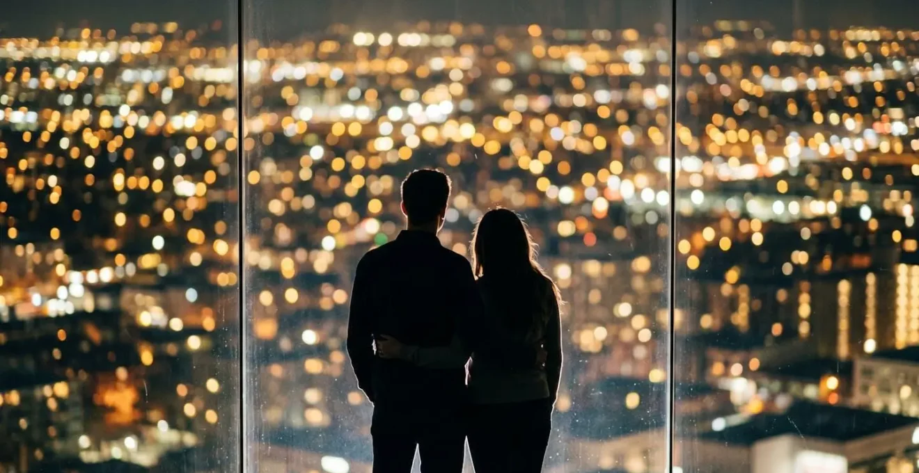
Is the Hong Kong Observation Wheel Worth the Ticket Price for Couples?
Absolutely. From a value-for-experience perspective, the Hong Kong Observation Wheel is one of the city’s best romantic bargains. In a city known for high costs, the fact that the Observation Wheel offers remarkably affordable pricing at HK$20 for adults (approx. US$2.60) makes it an almost unbeatable proposition. For a couple, the total cost is less than a single cocktail at a rooftop bar, yet it provides a 15-minute private, air-conditioned capsule with a magnificent, evolving view of the harbour and skyline.
The « worth » for a couple, however, goes beyond just the price. It’s about the type of romantic experience you are seeking. The wheel offers an « encapsulated spectacle »—a short, intense, and dramatic experience that is perfect for a classic photo-op or a moment of shared awe. It’s a structured and passive activity: you sit, you watch, you enjoy. It’s an iconic moment delivered efficiently.
In contrast, a free activity like the TST-WKCD walk offers a different kind of romance: an « immersive journey. » It requires more effort but offers unlimited time, the potential for spontaneous discovery, and quiet moments on waterfront benches. The table below compares these two romantic waterfront experiences, highlighting their different strengths.
| Factor | Hong Kong Observation Wheel | TST-WKCD Walk |
|---|---|---|
| Cost per Couple | HK$40 (US$5.20) for two adult tickets | Free (optional coffee/snack HK$50-100) |
| Duration | 15 minutes per ride (2-3 rotations) | 30-45 minutes walking at leisure pace |
| Experience Type | Elevated, encapsulated, air-conditioned spectacle | Ground-level, immersive, shared discovery journey |
| Romantic Moments | Intimate gondola, bird’s-eye views, sunset/night options | Hidden corners, waterfront benches, spontaneous photo stops |
| Physical Effort | Minimal (sit and enjoy) | Moderate (pleasant stroll) |
| Value Verdict | Exceptional value for money – iconic experience at budget price | Unbeatable free experience with unlimited time flexibility |
Is Bowen Road the Best Flat Running Path with City Views?
While the waterfront promenades offer an immersive, sea-level experience, Bowen Road provides a completely different, and arguably more unique, perspective for runners. Carved into the verdant hillside approximately 200 meters above the city, it’s not just a path; it’s an elevated viewing platform. The experience is what an urbanist might call a « borrowed landscape »—you are running through a shaded, jungle-like environment while « borrowing » spectacular, framed views of the Wan Chai and Central skylines below.
The sensory experience is the key differentiator. The waterfront is about the openness of the harbour—the breeze, the sound of ferries, the direct sun. Bowen Road is about the enclosure of nature—the shade from the tree canopy, the higher humidity, the sounds of birds and rustling leaves, with the city’s hum as a distant backdrop. It offers tranquility and natural immersion that the bustling harbourfront cannot match. For runners seeking a performance-focused run in a serene, shaded setting with breathtaking urban vistas, Bowen Road is unparalleled.
Contrasting the Sensory Experience: Bowen Road vs Waterfront Routes
Bowen Road, carved into the hillside above Wan Chai, offers an elevated ‘in the jungle looking down’ perspective approximately 200 meters above sea level, running 4 km through lush greenery with shade, humidity, and the sounds of nature. The relatively flat, paved path provides great views of Central and Wan Chai below, making it ideal for runners seeking a performance-focused route with natural immersion. In stark contrast, the TST-WKCD waterfront path provides a sea-level ‘immersive’ view directly engaging with Victoria Harbour, characterized by sun exposure, harbour breezes, and the sounds of the city. The waterfront is about wind, openness, and dynamic harbour activity, while Bowen Road delivers shade, controlled elevation, and forest tranquility, catering to completely different moods and visual desires for a run.
For the ambitious urban explorer, combining these two contrasting experiences into a single day offers a complete picture of Hong Kong’s recreational diversity. This « Sea to Summit » itinerary is a fantastic way to engage with the city’s varied pedestrian landscapes.
- Morning Session: Start with the flat TST-WKCD waterfront run at sunrise (6-7am) to enjoy cool temperatures and golden light over the harbour.
- Active Recovery: Take the MTR from Austin Station to Admiralty Station (approx. 10 minutes).
- Strategic Transport: From Admiralty, take a minibus or walk uphill to the Bowen Road starting point.
- Afternoon Session: Complete the Bowen Road 4km trail run in the shade, enjoying elevated city views and forest atmosphere.
- Cool Down: Descend back to Wan Chai or Admiralty, having completed two contrasting runs.
- Recovery: Hydrate and refuel at a Wan Chai cafe to celebrate your ‘sea to summit’ achievement.
Is It Easier to Walk from Austin Station or Kowloon Station?
This question addresses a classic urban planning challenge: the « last mile problem, » or in this case, the last 500 meters. The answer depends on your priorities: weather protection and luggage-friendliness versus the most direct route. While Austin Station is geographically closer, the journey is less comfortable, involving outdoor street crossings and navigating around construction zones.
Kowloon Station is the superior choice for most visitors, especially on hot or rainy days, or for those with luggage. The route is almost entirely indoors, utilizing the air-conditioned comfort of the Elements shopping mall and a connecting footbridge. It is a masterfully planned pedestrian corridor that insulates the walker from the city’s chaotic elements. Though slightly longer in distance, it is often faster and infinitely more pleasant. The walk from Austin Station, while shorter on paper, represents a more fragmented pedestrian experience, a series of « stops and starts » that disrupts the flow of the journey.
This comparison, drawing from data on station access to the park, illustrates the trade-offs between the three main rail access points.
| Station | Walking Time to Art Park | Route Type | Best For | Key Landmarks |
|---|---|---|---|---|
| Austin Station (MTR) | 10-15 minutes | Outdoor crossings, some construction areas | MTR commuters on fair-weather days; slightly shorter but less sheltered | Use Exit E at Xiqu, go under Austin Road West, emerge at D2 |
| Kowloon Station (MTR) | 15-20 minutes | Air-conditioned walk through Elements mall + footbridge | Airport arrivals, travelers with luggage, rainy days | Exit E3 through Elements, footbridge near Mango Tree |
| West Kowloon Station (High-Speed Rail) | 10-12 minutes | Direct elevated plaza access | Mainland China arrivals, major gateway for visitors | Exit arrival hall, follow signs to Art Park via elevated plaza |
Regardless of the station, navigating by visual landmarks is crucial. Once you are in the final approach, the key is to orient yourself towards the harbour and look for the vast green space—the Art Park itself is your biggest landmark.
Key Takeaways
- The Hong Kong waterfront is not one continuous path but a series of distinct ‘pedestrian rooms’ with different functions, from performance-running tracks to leisure-focused parks.
- Navigating successfully requires understanding the ‘urban seams’—the transitions between old promenades, new malls, and cultural districts—and choosing your route based on weather and comfort.
- The best experiences, from picnics to photography, come from understanding the unwritten social rules and the specific design intent of each space (e.g., wide-angle views from WKCD, discreet drinking etiquette).
How to Plan a Picnic Sunset at the West Kowloon Art Park?
Planning the perfect picnic at the West Kowloon Art Park is the ultimate reward for your waterfront walk. It is the culmination of the journey, transforming you from a pedestrian in motion to a citizen at rest, actively enjoying the public space. The key to a successful picnic here lies in understanding the park’s scale and rhythm. Spanning a massive 23-hectare park with a 2.4-kilometre harbourfront promenade, your choice of location within the park will define your experience.
The park is not a uniform green space; it’s a landscape designed with different zones, each offering a unique combination of views, accessibility, and atmosphere. Choosing the right spot is the first and most important step. Do you want unobstructed sunset views, a more secluded romantic corner, or a convenient spot close to amenities? Arriving early, especially on a weekend, is crucial to claim your desired « real estate » on the lawn. As the Sassy Hong Kong editorial team wisely advises, you must also prepare for the change in environment: « Always bring a jacket as the wind picks up after sunset ». This simple tip can make or break the comfort of your evening.
This « Picnic Spot Map » can guide your decision-making process:
- Spot A (Best for Unobstructed Sunset Views): The western edge of the main lawn, facing towards Lantau Island. Arrive by 5:30pm on weekends to secure prime real estate.
- Spot B (More Secluded and Romantic): The northern lawn sections near the Xiqu Centre offer a less crowded atmosphere with partial harbour views.
- Spot C (Best for Large Groups): The central open lawn is spacious and ideal for games and accommodating multiple picnic groups.
- Spot D (Closest to Toilets and Amenities): The eastern lawn near the M+ museum and Freespace is convenient for restroom access and food options.
- Spot E (Dog-Friendly Pet Zone): A designated area where pets can enjoy the space alongside picnicking families.
Your Essential Picnic Planning Checklist
- Logistics Audit: Confirm your arrival plan. Which station will you use (Kowloon for comfort, Austin for speed)? Have you screenshotted a map?
- Supply Chain Review: Where will you buy supplies? The supermarket in Elements for drinks and snacks, or are you bringing everything from home?
- Site Selection: Based on the « Picnic Spot Map, » which zone (A, B, C, D, or E) best fits your group’s needs (views, seclusion, convenience)? Have you checked the WKCD website for lawn closures?
- Comfort & Gear Check: Have you packed all essentials? This includes a blanket/mat, reusable cups, a trash bag, and the crucial post-sunset jacket.
- Etiquette Compliance: Mentally review the plan. Will you be discreet with beverages? Are you prepared to pack out all your rubbish to leave the space pristine?
By applying these planning principles, your sunset picnic will be a seamless and memorable conclusion to your exploration of Hong Kong’s magnificent urban waterfront.